Roll over image to zoom in
Click to expand


OMR 136.500
Inclusive of VAT
Easy Payment Plans with 0% interest for 12 months.
Starting from OMR 11.375/monthThe final amount depends on your bank
Details
FREE Shipping over OMR 20,000 from seller
Out of stock
Secure Transaction
Key Information
- Color: Black
- Display: 1.5" x 2.5" (3.8 x 6.3 cm); 3" diag (7.6 cm) Transflective Colour TFT
- Power: Battery
- Memory Type: 1.7 GB Built-in Memory and microSD™ card up to 32 GB (not included)
- Supported Capacity: 1.7 GB Built-in Memory, microSD™ card up to 32 GB (not included), 10000 Waypoints/favourites/locations, 250 Routes, 20000 Point Track Log and 250 Saved Tricks
- Input/Terminals: mini USB and NMEA 0183
Details
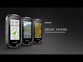
The Oregon 700 GPS and GLONASS handheld puts even more of the great outdoors at your fingertips. Whether you’re hiking, hunting, climbing, kayaking, trail riding or whatever, this rugged navigator is ready for anything. It features multilink wireless connectivity (Wi-Fi, Bluetooth and ANT+), Active Weather support with animated radar overlays, a 1-year BirdsEye Satellite Imagery subscription and a built-in 3-axis compass with barometric altimeter.
High-sensitivity Dual Gps And Glonass Satellite Reception For Better Performance In Challenging Environments Than Gps Alone
Redesigned Antenna Enables Better Reception And Performance; 3-axis Compass With Accelerometer And Barometric Altimeter Sensors
3-inch Sunlight-readable Touchscreen With Dual Orientation (Landscape Or Portrait View)
Expanded Wireless Connectivity (Wi-fi, Bluetooth®, Ant+® Capable); Supports Active Weather And Geocaching Live
Bluetooth®-enabled Smart Notifications¹ And Automatic Uploads To Garmin Connect™ Online Community
Product Specifications
Loading...
Loading...
Loading...
000000000001201868